|
Geodetic observatory Pecný
|
|
"G-Nut/Geb" is the end-user application designed to estimate receiver position in a static, quasi-kinematic or kinematic mode. Below applications are implemented using the G-Nut core library developed at the Geodetic Obsevatory Pecny. A comparison of supported capabilities is available in the feature matrix. All applications are released under the GNU General Public Licence. Figure shows an example of Geb's real-time coordinate monitoring in a quasi-kinematic mode using IGS RTCM clock and orbit corrections.

- Geb-PP is free open source lite application aimed for the post-processing mode.
- Geb-RT is free open source lite application aimed for the real-time processing mode.
DOWNLOAD
- the software download.
INSTALLATION
- instruction for the software installation.
EXAMPLES
- example configuration and outputs.
- Geb is an application providing enhanced capabilities while including all processing modes (RT and PP). The release is under preparation.
SUPPORT
- the current lite version is provided as a beta release and still undergoes final consolidations of the core library. The software is provided "as is" and without warranty of any kind. The support is given on a best-effort basis only. However, if you find G-Nut/Geb application(s) useful for your work, consider supporting its further development by ordering the enhanced version and we will try to give you a priority in the support.
Other related questions could be sent to This email address is being protected from spambots. You need JavaScript enabled to view it. (J.Dousa/P.Vaclavovic).
References
-
Vaclavovic P, Dousa J, Gyori G (2013), G-Nut software library - state of development and first results, Acta Geodynamica at Geomaterialia, pp 431-436, Vol. 10, No. 4 (172), doi:10.13168/AGG.2013.0042. PDF (or, alternatively, here).
News - in order to keep informed about news you can join the G-Nut mailing list
- 2013-03-10 - Release of Beta 0.9.0 version of G-Nut/Geb lite application.
"G-Nut/Tefnut" is the end-user application designed to estimate tropospheric path delays in various processing modes. Below applications are implemented using the G-Nut core library developed at the Geodetic Obsevatory Pecny. A comparison of supported capabilities is available in the feature matrix. All applications are released under the GNU General Public Licence.
Figure shows an example of Tefnut's real-time troposphere monitoring in real-time mode using IGS RTCM clock and orbit corrections.

- Tefnut-PP is free open source lite application aimed for the post-processing mode.
- Tefnut-RT is free open source lite application aimed for the real-time processing mode.
DOWNLOAD
- the software download.
INSTALLATION
- instruction for the installation.
- Tefnut is non-free application providing enhanced capabilities while including all processing modes (RT, NRT and PP), improved models and more flexible use.
The release is under preparation.
SUPPORT
- the current lite version is provided as a beta release and still undergoes final consolidations of the core library. The software is provided "as is" and without warranty of any kind. The support is given on a best-effort basis only. However, if you find G-Nut/Tefnut application(s) useful for your work, consider supporting its further development by ordering the enhanced version and we will try to give you a priority in the support.
Other related questions could be sent to This email address is being protected from spambots. You need JavaScript enabled to view it. (J.Dousa/P.Vaclavovic).
References
- Dousa J, Vaclavovic P (2014) Real-time zenith tropospheric delays in support of numerical weather prediction applications. Advances in Space Research (2014), Vol 53, No 9, pp 1347-1358, doi:10.1016/j.asr.2014.02.021, PDF.
- Dousa J and Vaclavovic P (2013), Real-time ZTD estimates base on Precise Point Positioning and IGS real-time orbit and clock products, In: 4th International Colloquium Scientific and Fundamental Aspects of the Galileo Programme, 4-6 December 2013, Prague, Czech Republic. PDF.
- Vaclavovic P, Dousa J, Gyori G (2013), G-Nut software library - state of development and first results, Acta Geodynamica at Geomaterialia, pp 431-436, Vol. 10, No. 4 (172), doi:10.13168/AGG.2013.0042. PDF (or, alternatively, here).
News - in order to keep informed about news you can join the G-Nut mailing list.
- 2013-03-10 - Release of Beta 0.9.0 version of G-Nut/Tefnut lite application.
"G-Nut/Shu" is the end-user application designed to process Numerical Weather Model (NWM) data field in support of tropospheric augmentation corrections for GNSS positioning, navigation and timing. The application is implemented using the G-Nut core library developed at the Geodetic Obsevatory Pecny. G-Nut/Shu is the application for tropospheric and meteorology parameter derivation from the numerical weather (NWM) data field. The software is designed to support a flexible functionality (questions related to the software could be sent to This email address is being protected from spambots. You need JavaScript enabled to view it. - J.Dousa or M.Elias):
- handle NWM products: ERA, WRF, ALADIN, HARMONIE, GFS (GRIB/NETCDF), parameters, coordinate systems, etc.,
- calculate selected tropospheric and meteorological parameters for requested area (grid) or user location (GNSS stations),
- support variants of temporal and spatial interpolation methods (linear/bi-linear/spline, vert2hor/hor2ver/integration {\ldots}),
- apply different approaches for vertical parameter fitting (power/logarithmic, height-/pressure-dependent, {\ldots}),
- use various ZWD surface calculations (integration, Askne-Nordius, GOP-ZWD/GOP-AN model variants,{\ldots}),
- exploit variants of ZWD vertical scaling (GOP, RTCA-MOPS, {\ldots}),
- model height-pressure relation using fixed/linear/zero T lapse rates,
- refractivity coefficients (SW 1953, TH 1974, BV 1992, FO 1999, RU 2002),
- densify original profile with a multiplication factor,
- adjust surface parameters in vertical parameter approximations,
- estimate tropospheric linear horizontal gradients from ZWD/ZHD grids,
- estimate combination ratio between water vapour and ZWD decays.
References
- Dousa J, Elias M (2014) An improved model for calculating tropospheric wet delay, Geophys. Res. Lett., 41, 4389–4397, doi:10.1002/2014GL060271.
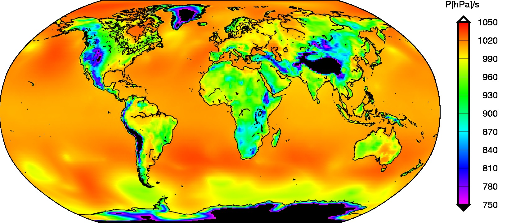
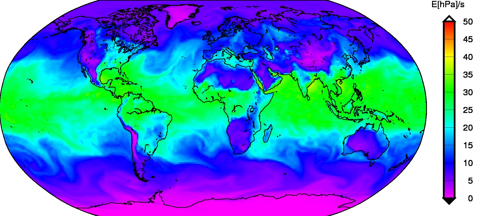
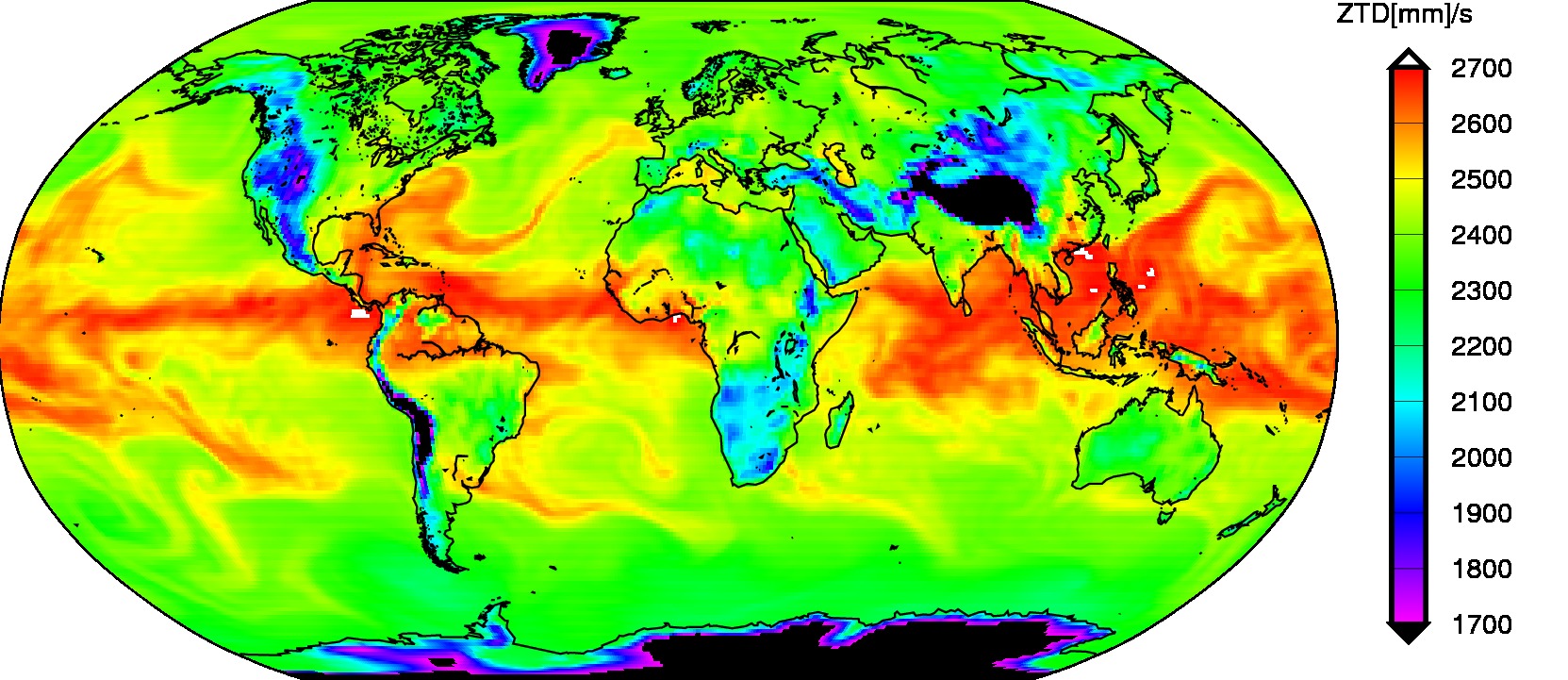
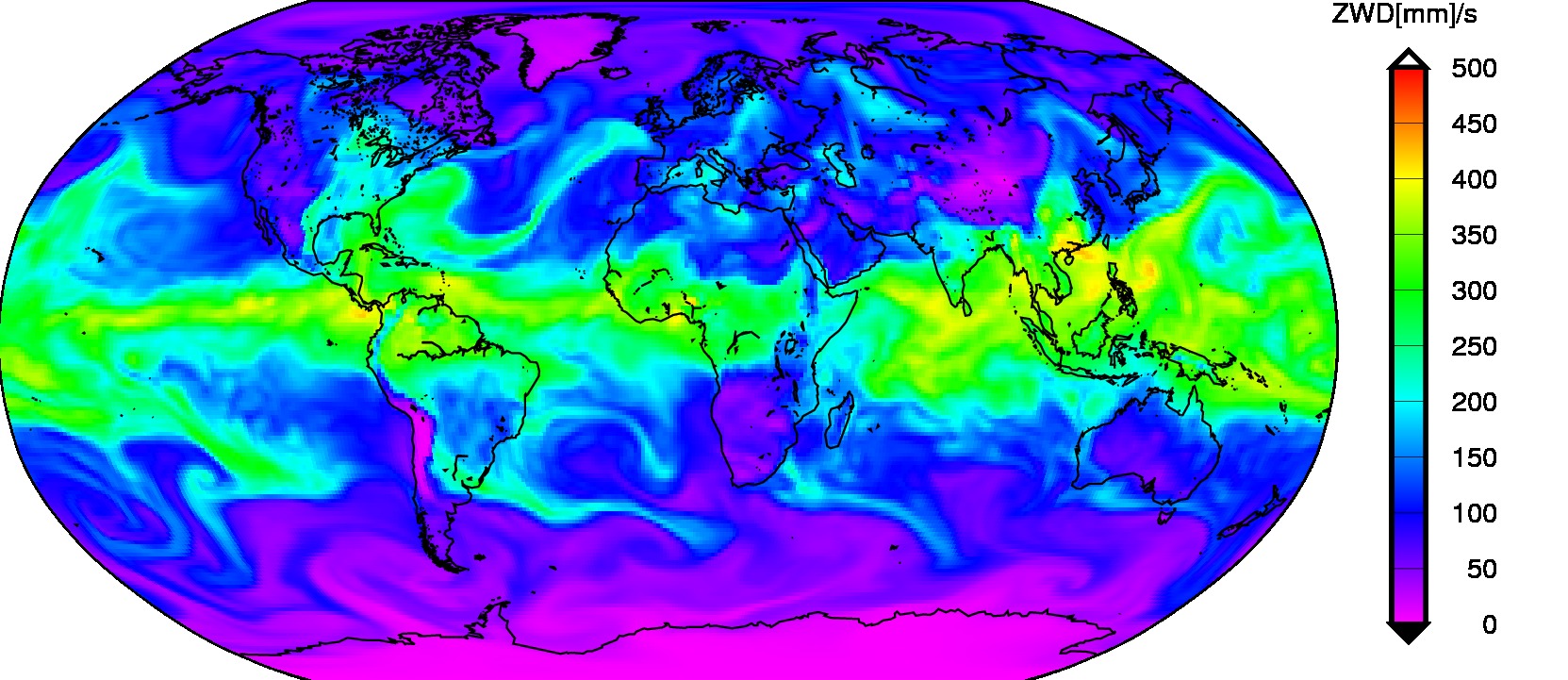
Figures show selected parameters - pressure, partial water vapour pressure, zenith total and zenith wet delays - derived from the global NWM data fields in support
G-Nut/Anubis application
G-Nut/Anubis is a command-line tool for a quality check of modern data from all available GNSS constellations providing full quantitative and qualitative control with support of GNSS navigation messages:
- observation statistics (counts of observations, signals, bands, satellites of GPS, GLONASS, Galileo, BeiDou, SBAS, QZSS, IRNSS)
- standard point positioning (if data and navigation messages provided for GPS, GLONASS, Galileo and BeiDou)
- pre-processing including clock-jumps and cycle-slip detection and other interruptions over all constellations, frequencies and signals
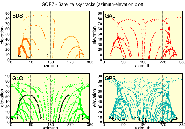
- satellite elevations and azimuths (if supported with constellation-specific navigation messages)
- elevation-specific histograms, satellite ascending/descending times for horizon and user elevation cut-off
- pseudo-range multipath and noise
- carrier-phase signal-to-noise ratio
- data gaps and small data pieces
- outputs in specific XTR and minimalistic standard XML formats
- other useful lists and statistics (satellite navigation data availability, satellite healthy status etc.)
The application is implemented exploiting the G-Nut core library developed originally at Geodetic Observatory Pecny (Václavovic and Douša, 2016). Since January 2018, it has been further maintained and developed by the G-Nut Software s.r.o. company which is a spin-off of the RIGTC/GOP. G-Nut/Anubis (free) provides a free application for the RINEX file qualitative and quantitative monitoring. It is released under GNU GPL. The G-Nut Software s.r.o. provides additionally Anubis Extra and Anubis Real-Time (RT) advanced commercial versions.
The software is provided "AS IS", without warranty of any kind and a support is given on a best-effort basis only. Questions could be sent to This email address is being protected from spambots. You need JavaScript enabled to view it. for free version, and to This email address is being protected from spambots. You need JavaScript enabled to view it. for commercial versions.
G-Nut/Anubis download (new: registration required)
GOP's Multi-GNSS BRDC files (new: doi:10.24414/c4ba-kf16)
REFERENCES
- Vaclavovic P, Dousa J (2016), G-Nut/Anubis - open-source tool for multi-GNSS data monitoring, In: IAG Symposia Series, Springer, Vol. 143, pp. 775-782, doi:10.1007/1345_2015_157, PDF.
- Václavovic P., Douša J..: Development Towards Advanced GNSS Data Quality Monitoring, In: Družicové metody v geodézii a katastru, Sborník referátů. Brno, ECON publishing, s.r.o, pp 76-81, 2015 (in english PDF)
- Vaclavovic P and Dousa J (2013), Anubis – a tool for quality check of multi-GNSS observation and navigation data In: 4th International Colloquium Scientific and Fundamental Aspects of the Galileo Programme, 4-6 December 2013, Prague, Czech Republic. PDF.
- 2020-07-18 - Released Anubis 2.3 - RINEX 3.04 support incl. BeiDou 3, newly distributed here
- 2018-08-01 - Released Anubis 2.2 - improved functionality including various handling of satellite health
- 2017-11-29 - Released Anubis 2.1 - version with major updates for supporting EPOS
- 2016-10-05 - Released Anubis 2.0 - teqc total summary, expt/have at elev cut-off, preliminary XML output and IRNSS & RINEX3.03, etc.
- 2016-01-27 - Released Anubis 1.4 - SNR support, SP3 format, Windows support, kinematic and high-rate processing
- 2015-01-28 - Released Anubis 1.3 - all-constellations/-bands/-signal pre-processing, advanced statistics, merged navigation messages etc.
- 2014-08-13 - Released Anubis 1.2 - navigation messages for all GNSS constellations, GPS, GLONASS, Galileo, BeiDou standard positioning
- 2014-04-29 - Released Anubis 1.1 - qualitative QC for GPS&GLO, bancroft positioning, boost-independent version, RINEX3.02 support
- 2013-08-16 - Released Anubis 1.0 - multi-path detection for all constellations, signals and frequencies
- 2013-03-10 - Released Anubis 0.9 - beta version
"G-Nut/Apep" is the end-user application designed to analyse parameter time-series derived from positioning (coordinates), atmosphere monitoring (tropospheric zenith path delays) or other parameters (e.g. meteorologic). The application is implemented using the G-Nut core library developed at the Geodetic Obsevatory Pecny. The application will be released under the GNU General Public Licence.
- G-Nut/Apep is the application for time-series analysis. The application is still under development.
Related questions could be sent to This email address is being protected from spambots. You need JavaScript enabled to view it. (J.Dousa/M.Elias).
News - in order to keep informed about news you can join the G-Nut mailing list.