EUREF-Czech-2009 campaign
by Jan Douša, Vratislav Filler, Jan Kostelecký, Jakub Kostelecký, Jaroslav Šimek
This report has been submitted for evaluation by the EUREF Technical Working Group in Gaevle, Sweeden, June 1, 2010. The full report is available in the proceedings of the EUREF symposium 2010.
1 Introduction
The reasons for ETRS89 implementation in the Czech Republic were threefold:
- Harmonization of the surveying and mapping legislation with IAG/CERCO/EuroGeographic and EC recommendations and directives
- Fostering the use of GPS technique and development of GPS based applications by a broad user community
- Improved realization of the classical national user geodetic reference system S-JTSK
The first expansion of the ETRS89 to the east was realized by the EUREF-CS/H’91 campaign in 1991. Eleven stations of the fundamental national geodetic network were observed by the former Institute of Applied Geodesy, Frankfurt am Main (present-day BKG) on the territories of Hungary (5 sites) and the former Czech and Slovak Federal Republic (6 sites). Only three of them (Pecný, Kleť, Přední příčka) are located on the territory of the Czech Republic and today none of them is operated as a permanent GNSS station with the exception of Pecný where the GOPE IGS/EPN station is located about 90 m apart. Note, that in processing of the EUREF-CS/H’91 campaign, which was performed in cooperation between BKG and RIGTC, no precise GPS orbits were available since it had been done in 1992 before a regular IGS operation started. Later, in 1993 the solution was slightly improved after the ideas by W. Gurtner and M. Rothacher by computing ad hoc “precise orbits” using several fiducial European permanent stations. This solution was validated by the EUREF TWG in 1994 as “class B”.
The Czech national user reference system (S-JTSK), which is one of the mandatory geodetic reference systems allowed in the Czech Republic and is used as a principal system for all legal mapping and surveying work, originates in 1927. Besides a wrong placing on the Bessel ellipsoid, wrong orientation and scale the realization of this system (first to fifth order national triangulation network) suffers from inhomogenities and many local deformations so that a large number of the triangulation points with ETRS89 coordinates regularly distributed over the entire territory is necessary to detect and rectify them. In 1992-1994, a sequence of campaigns was carried out to set up a national reference frame for the ETRS89 realization:
- CS-NULRAD (1992) – realization of the Zero-order network (6+13 stations) as a first densification of the frame set up by the EUREF-CS/H’91 campaign in the Czech and Slovak Federal Republic in 1991; processing done by RIGTC-GO Pecný using precise orbits kindly provided by Y. Bock of SIO.
- CS-BRD (1993) – the campaign to connect the GPS networks of the Czech Republic and Germany. Some of CS-NULRAD stations were re-observed, but finally the resulting accuracy of the re-processed coordinates was similar to that of the previous campaign; processing done by RIGTC-GO Pecný using precise IGS orbits.
- DOPNUL (1993-1994) – second order densification of the EUREF based reference frame on the territory of the Czech Republic stemming from the CS-NULRAD and CS-BRD campaigns and resulting in 176 stations (average distance of 25km) with both ETRS89 and S-JTSK coordinates; processing done by RIGTC-GO Pecný using IGS precise orbits.
The above mentioned campaigns represent a hierarchy of the sequential ETRS89 densification on the territory of the Czech Republic. The national CS-NULRAD and DOPNUL campaigns, which were based on the EUREF-CS/H’91 campaign, were not submitted to the EUREF TWG for validation. None of the stations is currently operated as a permanent GNSS station.

|
The active GNSS positioning system (CZEPOS), which was developed in the Czech Republic from 2004 to 2006, has been after an about one-year provisional operation fully operational since January 1, 2007. In 2008 and 2009, it was upgraded by implementation of the new stations, software tools and services. In April 2010, it consists of 54 permanent GPS/GNSS stations 27 of which are regularly distributed over the territory of the Czech Republic and the remaining 27 are located in the neighbour countries along the Czech border as a part of the national GNSS positioning systems of these countries. CZEPOS uses the data of these stations on the basis of bilateral agreements with their operators. Because the realization of ETRS89 coordinates in the Czech Republic comes from the early GNSS era, i.e. before the International GNSS Service (IGS) was established, the ETRS89 coordinates of CZEPOS stations were preliminary estimated from the first permanent GPS observations.
A new realization of the reference frame based on the ETRS89 coordinates of permanent GNSS stations in the Czech Republic is described in this report. This represents the first step for a further large scale densification represented by ETRS89 coordinates of about 46 500 points in the Czech Republic with an average distance of 2 km.
2 Campaign configuration
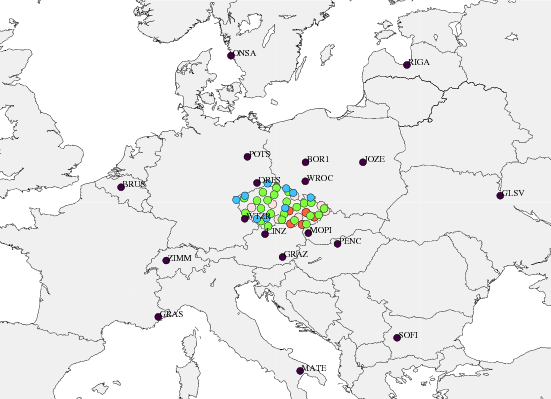
The EUREF-Czech-2009 campaign consists of available permanent GPS stations on the territory of the Czech Republic (44) and EPN stations in other European countries (18). The latter were selected using the following criteria:
- EPN Class A stations with defined coordinates and velocities.
- Station with smooth coordinate time-series in the EPN cumulative solution.
- Fiducial stations within the EPN cumulative solution.
- Location in the close surrounding of the Czech Republic.
- In distance to all directions from the middle of the network (approximately 1000 km).

|
The remote stations were included to minimize possible biases on the fiducial stations and to support the estimation of absolute values of tropospheric parameters.
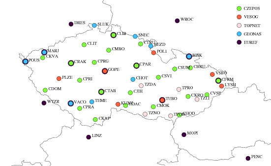
All Czech stations are plotted in Figure 1 and additionally introduced EPN stations in Figure 2. Only 8 from all the stations were processed for a period shorter than 3 years.
The station Sněžka (SNEC) is very well known for its problems during winter periods. The station is located on the top of the highest mountain in the Czech Republic which is well known for extremely severe weather conditions so that from early autumn till late spring its radome is usually covered with snow or, in worst case, even with a few centimetres of ice crust. The effects reached even more than decimetre in horizontal position, see e.g. EUREF CB web page coordinate time-series. For this reason, only data from snow-free periods (June-September, 2005-2009) were included in the daily processing. In 2009, the monumentation (an old building) was destroyed and the station was moved to another pillar. The reason why SNEC had to be included in the campaign was that the baselines using data from this station were observed and calculated in the past and will be probably necessary for selected local densifications.
Similar problems during winter periods can be seen in daily coordinate time-series of two other stations located at the top of high mountains in the region of Moravia – Lysá hora (LYSH) and Biskupská kupa (BISK). Nevertheless, the problems were significantly smaller and the data of winter periods were not excluded in daily processing, but only in the final combination if outliers were detected.
- Prev
- Next >>